Remote Sensing Technology Market Size (2024 – 2030)
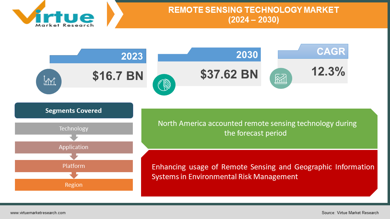
The Remote Sensing Technology Market was valued at USD 16.7 billion in 2023 and is projected to reach a market size of USD 37.62 billion by the end of 2030. Over the forecast period of 2024-2030, the market is estimated to grow at a CAGR of 12.3%.
Remote sensing is a geospatial technology that throws and reflects electromagnetic (EM) radiation from the Earth's terrestrial, atmospheric, and marine ecosystems to detect and handle the physical characteristics of an area without physical contact. This data collection technique typically sets up passive and active sensor technologies based on aircraft and satellites. Passive sensors gather radiation reflected or emitted by an object or the surrounding environment as a reaction to external stimuli. Reflected sunlight is the most usual source of radiation computed by passive remote sensing. Active sensors depend on internal stimuli to gather data, emitting energy that tests objects and areas before measuring the energy reflected from the aim. IoT in agriculture exhibits crops on a screen and offers information to farmers for efficient farm management by using remote sensors, robots, drones, and PC imaging.
Key Market Insights:
-
Remote sensing is significant for mapping habitats, assessing biodiversity, and handling the environment. In order to encourage ecosystem management and conservation efforts, satellite imaging and remote sensing information are utilised to track changes in land cover, monitor deforestation, computer water quality, detect pollution, and monitor wildlife populations.
-
The eco-friendly management of natural resources, such as forests, water supplies, minerals, and energy sources, is helped by remote sensing services. In order to conserve resources and enhance their use, remote sensing data is collected to detect and track changes in the forest cover, identify mineral deposits, evaluate the quality and approachability of water, and optimize energy exploration and extraction activities.
-
By offering timely information for disaster preparedness, response, and recovery functions, remote sensing services are crucial to emergency response and disaster management efforts. Aerial surveys and satellite imaging ensure quick evaluation of disaster-affected areas, damage analysis, environmental hazard controlling, and help for search and rescue efforts during natural calamities like hurricanes, floods, wildfires, and earthquakes.
Remote Sensing Technology Market Drivers:
Enhancing usage of Remote Sensing and Geographic Information Systems in Environmental Risk Management
A revolutionary modern sensor design is modifying remote sensing and GIS technologies. It is applied for spatial information analysis, mapping, and distribution. Applying satellite or aircraft pictures, distance-based remote sensing extracts spatially accurate features of the Earth's water and land surfaces. The GIS data and parameters are later analysed, handled, stored, and shown. Utilising remote sensing data with different spatial and temporal resolutions, environmental variables can be evaluated. Applying GIS, combined strategies and solutions are grown by integrating geospatial data from remote sensing and other sources, demographics, and socioeconomics. Modern image processing techniques and algorithms enable the creation of a global environment database faster. Environmental risks caused by humans or natural calamities pose a developing threat to local, regional, and international groups. The operations and health of modern civilization rely on timely and effective ecological risk assessment and control. These technologies facilitate the generation of geo-referenced reports and maps, which can be used to create comprehensive environmental solutions.

Remote Sensing Technology Market Restraints and Challenges:
Difficult data formats and complex processing techniques of huge data
Remote sensing and geospatial data & mapping have updated rapidly in past decades. Remote sensing has many uses. The demand for geospatial data has resulted in the development of numerous remote sensing technologies. Resultantly, various government agencies, research organisations, and private companies utilise remote sensing to gather data. While remote sensing provides better utilization and approachability to tough problems, it also holds numerous challenges. Huge data volumes and complex data formats with detailed processing are major concerns. Resultantly, users will likely turn to open GIS data formats and real-time data processing to apply spatial data better. Moreover, the present satellite data coverage restrictions are evident and demand to be addressed. For instance, polar-orbiting LEO imagers particularly cover the entire world in one day, exiting natural occurrences with high spatial and temporal variability. High-orbit Geostationary Observations (GEO) tackle this restriction by offering regular day to day observation of the same object.
Remote Sensing Technology Market Opportunities:
Employment of artificial intelligence and machine learning in remote sensing:
Artificial Intelligence (AI) and Machine Learning (ML) are earning enormous traction in geomatics. These technologies can positively develop and disrupt the field by augmenting and substituting elements of conventional remote sensing, modelling, and assimilation techniques. The Internet of Things (IoT) and SmallSats will consistently generate new environmental data. This is anticipated to propel the growth of the remote sensing technology industry. The machine learning market is rapidly escalating. Because machine learning models can be flexible to nonlinearity, they are more efficient and precise. There are various applications in remote sensing and geosciences, encompassing retrieval algorithms, code acceleration, crop disease detection, and bias alteration, constituting of aerosol items, vegetation indices, retrievals, trace gases, land surface, and, most recently, ocean products. In turn, this heightens the workload of remote sensing analysts and experts. Several organizations depend on remote sensing and imagery data, which they get and analyse using modern data analysis methods. The data acquisition can be escalation by utilising spatial modelling, machine learning, and deep learning, which will permit the algorithms to learn to understand and process ever-escalating amounts of data.
REMOTE SENSING TECHNOLOGY MARKET REPORT COVERAGE:
|
REPORT METRIC
|
DETAILS
|
|
Market Size Available
|
2023 - 2030
|
|
Base Year
|
2023
|
|
Forecast Period
|
2024 - 2030
|
|
CAGR
|
12.3% |
|
Segments Covered
|
By Technology, Application, Platform, and Region
|
|
Various Analyses Covered
|
Global, Regional & Country Level Analysis, Segment-Level Analysis, DROC, PESTLE Analysis, Porter’s Five Forces Analysis, Competitive Landscape, Analyst Overview on Investment Opportunities
|
|
Regional Scope
|
North America, Europe, APAC, Latin America, Middle East & Africa
|
|
Key Companies Profiled
|
Maxar Technologies, Esri, General Dynamics Mission Systems, Inc., Hexagon AB, Lockheed Martin Corporation., Orbital Insight, Planet Labs PBC.
|
Remote Sensing Technology Market Segmentation: By Technology
-
Active Sensing
-
Passive Sensing
Passive Sensing segment is anticipated to hold the major share owing to its biggest market share. Passive remote sensing technology handles and analyses surface features by computing the sunlight reflected on Earth's surface. As opposite, Active sensing technology, emits its light to control and analyse surface features. Dynamic sensing technology circumvents the incapacity of passive sensors to operate at night.
Remote Sensing Technology Market Segmentation: By Application
The Defence and Intelligence segment held the biggest market share in recent years and expected to continue the same. The segment's biggest revenue share is dedicated to the capacity of these sensing technologies to carry out covert applications without placing human lives at risk. The key applications of remote sensing technologies in the military are intelligence collecting and navigation support. As more and more military units employ technologies for their functions over the next seven years, it is anticipated that the segment will observe steady development. Other uses involve cultivation & living resources, disaster handling, infrastructure, and weather, among others, and military and intelligence.
Remote Sensing Technology Market Segmentation: By Platform
The Aerial systems segment held the biggest market share in recent years and anticipated to grow the same manner. The escalating use of unmanned aerial vehicles (UAV) in aerial mapping is the key driver of the segment's rapid expansion. The application of aerial mapping decreases human error and grows the overall speed of surveying and area coverage. Furthermore, they can help in the surveying of areas unapproachable to satellite images, thereby increasing their utility. These elements make aerial platforms the platform of choice for remote sensing applications. The area of satellite-based sensing is also expected to widen steadily, mainly due to satellite-based weather forecasting applications.
Remote Sensing Technology Market Segmentation: By Region
-
North America
-
Asia-Pacific
-
Europe
-
South America
-
Middle East and Africa
From the above, it is anticipated that North America holds a major share in the global market. The application of remote sensing technology in accurate agriculture applications is expected to propel market expansion over the future period. The technology devices water resource managers with techniques to reduce the effects of dry spells and drought and suite crop irrigation needs.
Over the next few years, Asia Pacific is anticipated to grow at an extensive rate throughout forecast period. This is owing to the enhancing adoption of earth observation applications for infrastructure growth. Nations such as India, China, and Japan are introducing satellites to better their earth observation capabilities and development assistance. The Indian Space Research Organization (ISRO) had confirmed plans to introduce ten extra earth observation satellites in the upcoming years. Furthermore, government initiatives for urban infrastructure development, such as India's Smart City Mission, are expected to push the market growth in the nation and region.

COVID-19 Impact Analysis on the Remote Sensing Technology Market:
The COVID-19 pandemic has detrimentally impacted numerous industries. Resultantly, stakeholders and governments request strategies to revive normalcy while effectively fighting the pandemic. However, governments and businesses closely related to the satellite and space industries react differently to the scenario. Nevertheless, airborne and satellite data can help in identifying indirect impacts of the pandemic through remote sensing by applying historical remote sensing data as a baseline and then recording the economic, sustainable, and social effects caused by the pandemic outbreak.
Owing to the enhancing need to quantify the social and economic impact of the pandemic outbreak, the necessity for crisis management and business intelligence has enhanced dramatically. Presently, companies that offer satellite data services are actively dedicating to the response efforts by offering processing and storage capacities for modelling and other research requirements and analysing the pandemic's overall effect. Companies also offer earth observation imagery for monitoring remotely placed infrastructure.
Latest Trends:
The potential for remote sensing to enhance the resilience of agricultural production techniques
Latest food production and agriculture techniques are under pressure from lowering land and water resources, climate alteration, and enhancing production costs. Also, the COVID-19 crisis threatens to explode food supply and production techniques. These elements destroy the economic and environmental sustainability of present and future food supply systems. Technological and scientific modifications are needed to feed a quicker expanding global population. Science has bettered our knowledge on how components of the agricultural system communicate, from the cell to the field.
Nonetheless, to precisely measure field-scale phenotypic data and combine big data into prescriptive and predictive management techniques, latest advances in AI and remote sensing have huge role to play. While agriculture is consistently growing, substantial alterations are needed to keep up with climate change. Agricultural firms and researchers have been figuring out ways to combine cutting-edge technologies like remote sensing into agriculture systems to answer concerns about manufacturing enough food for a rapidly escalating global population.
Key Players:
-
Maxar Technologies
-
Esri.
-
General Dynamics Mission Systems, Inc.
-
Hexagon AB
-
Lockheed Martin Corporation.
-
Orbital Insight
-
Planet Labs PBC.
Recent Developments
-
In July 2023, a company in digital reality solutions named Hexagon, bought HARD-LINE, a Canada-based automation company expert in operating mines. This acquisition tightened Hexagon's position in the mining market and aided the company to provide a more comprehensive suite of solutions for mine operators.
-
In January 2023, Lockheed Martin Corporation introduced Lockheed Martin LM 400, a flexible, medium-sized satellite personalised for military, civil, or commercial uses. To encourage remote communications, radar, sensing, imaging, and persistent surveillance LM 400 spacecraft bus design is very beneficial.
-
In December 2022, OSASI Technos Inc. and Hexagon AB partnered to provide futuristic disaster management and monitoring services. It assists governments to figure out, predict, and simulate upcoming crises using wide-area remote monitoring systems with 3D visualization abilities.